Alpine crossing Merano - Lake Garda

The completion of the crossing of the Alps and the extension of the E5 from Merano to Lake Garda.
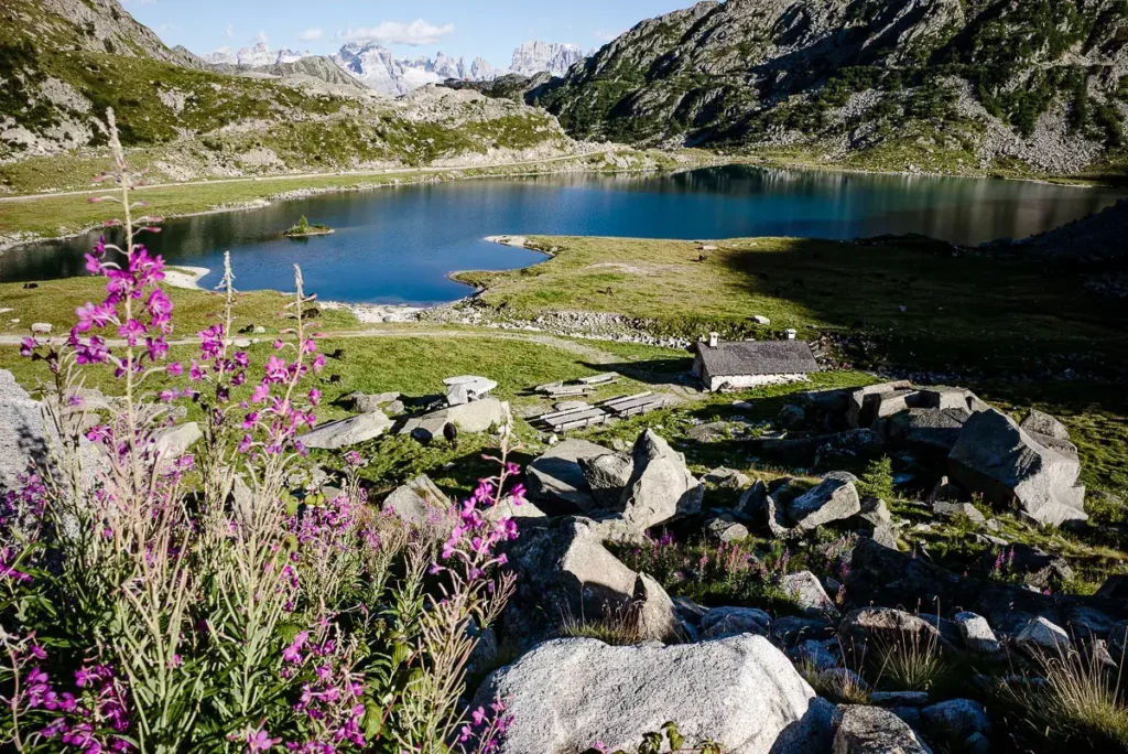
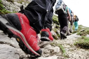
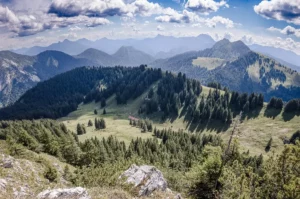
The well-known E5 does not end in Merano/Meran, but rather builds up to a brilliant finale from here to the finish at Lake Garda. The landscape appears more southerly, the mountains are partly lovely, partly rugged and unexpectedly high alpine. The very first stage takes you into the dream landscape of the Vintschgau. Before reaching the highest peak in Tyrol, the 3,905 m Ortler, you hike into the Martell and Ulten valleys and, after crossing the language and national border, on into the Val di Sole. The name says it all and the view south to the Brenta and Adamello is spectacular. The peaks of the Brenta Dolomites form a rugged contrast to the glaciated Adamello, and we have the best view of them from the famous Grafferhütte and, almost needless to say, another hospitable top base on our route. At Lake Garda, you have actually reached the southern edge of the Alps and can (assuming you have completed the E5 from Oberstdorf to Merano) report on a complete crossing of the Alps.
Program and schedule
- Mountain guide:in with the appropriate necessary qualifications
- 5 x nights in cabins
- 2 x overnight stay in hotel/ inn
- 7 x half board
- 4 - 5 x transfers by cab and bus
- Return from Riva del Garda to Merano
- Mountain railroads & lifts according to program
- Free participation in the Online Training: Alpine Crossing - Preparation (1 h)
Additional costs
- Snacks, drinks
- Arrival, possibly parking fee
Day 1: Meeting point is at 10:00 am at the Texelbergbahn valley station. From there, the Texelbahn cable car takes us up to the Giggelberg (1,565 m). Here starts one of the most beautiful sections of the Merano High Altitude Trail through the wild landscape of the Texel Group. Numerous vantage points offer us magnificent views of the Adige Valley deep below and across to the glaciers of the Ortler region. A highlight is the suspension bridge over the 1000-step gorge before the cable car takes us from Unterstell back down into the valley to Naturno. Overnight stay at the hotel. Ascent 450 hm / descent 700 hm, time 3 h
Day 2: With public transport we go in the morning from Naturns to Latsch. From there we reach comfortably with a small chair lift to the Tarscher Alm (1.940 m). There we start our ascent up to the Tarscher Pass (2,530 m). We continue to enjoy the view of the Ortler group and can already see the steep rocky peaks of the Dolomites in the distance. We hike down to the Kuppelwieser Alm, where we can enjoy an excellent apple or poppy seed strudel! After a short hike a bus takes us via St. Nikolaus to St. Gertraud. Overnight stay in St. Gertraud. Ascent 600 hm / descent 600 hm/ walking time 5 h
Day 3After breakfast we start our hike to the Rabbi Joch at 2.449 m and over the Haselgruber hut and the Haselgrubersee. During a break we enjoy the great view. Afterwards we descend in the direction of Piazzolo. From there a cab takes us further into Val di Sole until we reach the rustic Albergo Lago Rosso (1,178 m). The rustic inn is located in the middle of the Adamello Brenta National Park on the unique Lake Tovel. Overnight stay at the Albergo Lago Rosso. Ascent 1,000 m / Descent 1,100 m / Hiking time 6 h
Day 4Our crossing of the Brenta starts with the ascent through the Val di San Maria della Flavone to the Groste Pass (2,442 m). First we take a shady path through the woods. Later we reach the Malga Flavona alpine pasture, where our path is now narrow and steeply uphill. A lonely and green high valley rewards us for our efforts. Above the tree line, a steep mountain path leads to the pass. Only a few minutes of descent separate us from the Rifugio Graffer (2,261 m) in the middle of the "Madonna di Campiglio" ski area. Grandiose views to the Latemar, Mendelkamm and the Sarntal Alps delight us the whole day. Ascent 1.265 m / Descent 250 m / Walking time 6 h
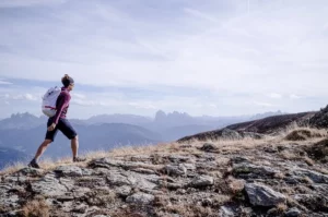
Day 5: Dream hiking day: Past wild rock towers, the rock face "Crozzon di Brenta" and the "Cima Brenta" we hike through the heart of the Brenta Dolomites. After a short rest at the Tuckett hut we start on a spectacular path over the Brentei hut to the "Bocca di Brenta". At the end of a huge rocky basin we climb over short passages secured by steel ropes to the top of the "Bocca di Brenta" pass at 2,552 m above sea level. Our destination for the day, the Rifugio Pedrotti is located in the middle of the impressive rocky scenery of Cima Brenta Bassa 2.812 m, Cima Brenta Alta and the Croz del Rifuguo 2.568 m. A breathtaking view! Ascent 850 m / Descent 650 m / Walking time 6 h
Day 6: Early the next morning we hike past the south-facing rock faces of the Brenta. On the opposite slope we see the Pedrotti hut only as a small dot between the immense Brenta rocks. Slightly ascending we reach the Forcolotta di Noghera (2,423 m), where we may be able to observe a herd of climbing chamois. First steeply down, then across we continue from there to the Agostini hut, where we strengthen ourselves for the descent to the Cacciatore hut. Overnight stay at the Cacciatore hut. Ascent 840 m / Descent 190 m / Walking time 5 h
Day 7: We drive to the beautiful Tenno Lake. The last and very varied stage leads us up to the San Pietro hut (963 m). From here we have a breathtaking view of the destination of our great mountain hiking week: Lake Garda. We take a short rest at the hut and enjoy the view of our destination. We slowly descend past the waterfalls of Varone. Through olive groves we hike the last kilometers to the shore of Lake Garda at Riva del Garda. A great long distance hike comes to an end! Overnight stay in a hotel on Lake Garda. Ascent 410 m / Descent 830 m / Walking time 5 h
Day 8: Joint return journey to the Texelberg cable car.
Note on program changes:
All courses and guided tours are conscientiously organized and carried out in accordance with the safety standards of the Vivalpin Mountain and Ski School with qualified specialists (e.g. mountain and ski guides, mountain hiking guides, etc.). The provisional tour program may be adjusted for safety-related reasons, such as bad weather, dangerous conditions, unforeseen natural events or inadequate conditions of the participants. The final program will be decided by the guide on site.
Good physical condition, sure-footedness, head for heights and endurance for daily stages with approx. 8 kg luggage of approx. 7 hours walking time, ascents up to 1.300 Hm and 5 hours in the ascent, descents up to 1.250 Hm. Good preparation is half the battle for multi-day hikes: Get used to your mountain boots and to carrying a backpack. The best way to practice this is on hikes with comparable altitude differences. For your specific preparation we recommend our Intensive training in surefootedness and head for heights.
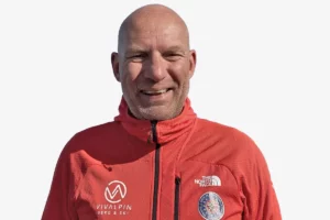
"The hike from Merano to Lake Garda is my personal recommendation. The stages are fantastic, sometimes wild, sometimes almost Mediterranean and, unlike the classic E5 from Oberstdorf to Merano, there is less hustle and bustle. You could spend weeks in the Brenta Dolomites alone (a UNESCO World Heritage Site)."
Thomas Storck
UIMLA Mountain Guide
Member of the VIVALPIN Competence Team


Similar tours

Online training: Crossing the Alps

If you are planning to cross the Alps, there is a lot to consider. You should be able to correctly assess the requirements and difficulties, be familiar with objective and subjective dangers and be in control of your equipment.you will learn everything you need to know about preparation, packing your rucksack correctly, food, the special "hut life" from an experienced mountain professional...

Palaronda Trek
Cimo della Pala, Rifugio Rosetta, Passo Pradiadali, the names melt in the mouth. And indeed, the Pala Dolomites are something for alpine connoisseurs. For ski tourers, freeriders, climbers and, in particular, mountaineers and hikers. Because although the summit panorama is characterized by steep pinnacles and towers, mountain forests and plateaus are hidden in between...
Private mountain guide:in
Want a dream tour? We will be happy to organize an optimally qualified guide for you and your friends, family or company. Over 80 mountain guides are looking forward to your dream tour with you. They have turned their hobby into a profession and will accompany you with great commitment after meticulous preparation. There are virtually no limits: From...

Ammergau alpine crossing
The Bavarian fairytale king Ludwig II not only left his descendants magnificent castles, but also many a royal riding and hunting trail that was created especially for the eccentric monarch in the Bavarian Alps. This wonderful pleasure hike follows parts of these historic paths, as well as the most beautiful sections of the "Maximiliansweg", which was only opened at the beginning of the 1990s...
Karwendel High Altitude Trail

Karwendel - that is the epitome of untouched nature and rugged peaks, of austere beauty and wild solitude. However, the Karwendel Höhenweg cleverly finds the weak points between the inaccessible mountain ranges and is good and enjoyable for sure-footed and experienced hikers accompanied by a mountain guide.
Intensive training in surefootedness and head for heights

Surefootedness is one of the elementary skills for all mountaineers, hikers and climbers. Let a mountain professional show you important tips, tricks and exercises so that you can be more experienced and effective in the mountains in the future.
Dolomites Via Bellissima, South Tyrol
Which is the most beautiful Dolomite crossing? We asked a local who should know. Florian Harrasser comes from Bruneck, he has been Simon Gietl's rope partner for many years and is a passionate mountain hiking guide. The tour he has planned for us is not included in any hiking guide and is an absolute highlight. Because it connects the most beautiful spots in the Dolomites...

Alta Via No. 1 Dolomites High Trail
Enjoy the unique landscape on one of the most beautiful, technically easy alpine traverses on the Alta Via No. 1 Dolomites High Trail. Wonderful resting places, deep blue lakes and cozy huts with the best Italian cuisine make the Alta Via No. 1 a truly unique tour.
Alpine crossing Tegernsee - Sterzing

The Alpine Crossing Tegernsee - Sterzing is our easiest route across the Alps and the ideal introduction to the world of long-distance hiking. Technically easy paths and comfortable bases make the tour a feasible adventure for every:n.

Alpine crossing Garmisch - Merano
On the crossing of the Alps from the Zugspitze to Merano you start at the highest point of Germany and have from here the route to the south in the best view. On often lonely paths and climbs you get to know the Alps from their best sides.