Zugspitze Pure Valley

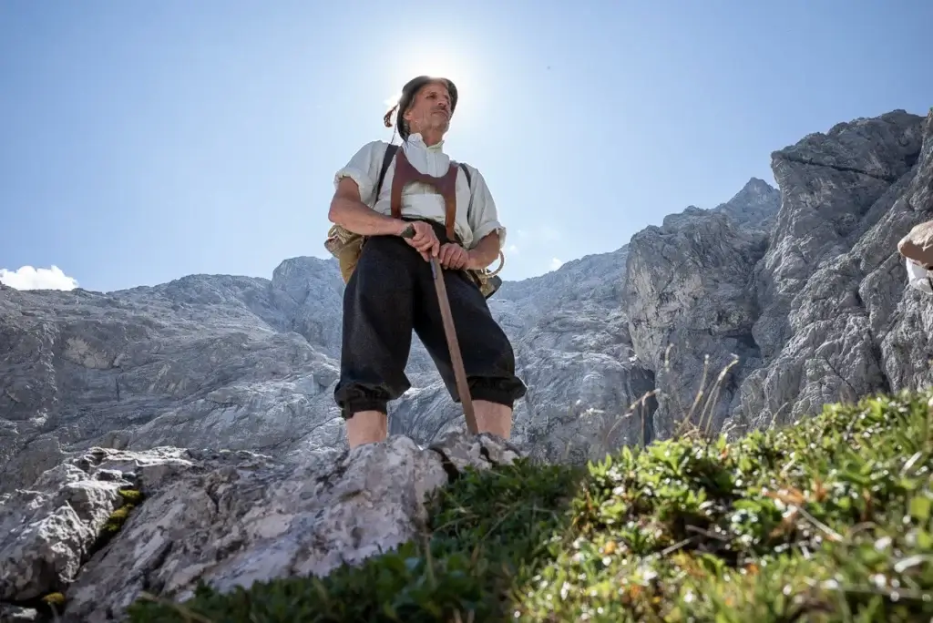
The way of the first climbers - in 2 days on the Zugspitze.
The first ascent of the Zugspitze was achieved on August 27, 1820 by Lieutenant Josef Naus with his mountain guide Johann Georg Tauschl and Naus' messmate and officer's apprentice Maier.
This climb is the easiest (but relatively long) way to the Zugspitze. It cleverly uses the "weak points" of the mountain and approaches the summit in a wide arc first from the north, then from the east, to finally reach the summit after a dreamlike hike from the south, over steep scree and rocks.
Stories about the Zugspitze and the 10 best climbs you can find on vivalpin.blog
Program and schedule
- Mountain guide:in with the appropriate qualifications
- 1x overnight stay at the Reintalanger hut
- Rich breakfast and multi-course dinner menu
- Leki trekking poles on loan
- Free participation in the online training: Crossing the Alps - preparation (1 h)
Additional costs
- Descent with the Zugspitzbahn
- Eintritt Partnachklamm
- Snacks, drinks
- Arrival, possibly parking fee
Day 1: The ascent begins with a bang. From the sunny ski stadium, you stroll through the crowds of tourists to the Partnach Gorge. After the payment point, the path leads through tunnels, over footbridges and massive rock steps, secured by wire ropes and railings. You are well advised to have your rain jacket ready for the foaming spray. After half an hour of looking and marveling, you return unexpectedly to the glistening sunlight after a final tunnel. The Partnach becomes a gentle river again, babbling lazily along. From the exit of the gorge, you walk along wide paths and forest roads without any significant incline. The first overnight stop, the Bockhütte at 1,052 m, is reached after a good 3 hours. A little later, the trail loses itself in a narrow path and you should actually come across the "Blaue Gumpen" in this area, which until two years ago still shimmered deep blue through the green forest. However, the heavy rainfall in the summer of 2005, together with mudslides and massive flooding, meant that the "Blaue Gumpen" have probably disappeared forever. Our destination for the day, the idyllically situated Reintalangerhütte at an altitude of 1,369 m, is getting closer and closer. A large part of the route is already behind us, but we have only covered a good quarter of the difference in altitude. Overnight stay and half board at the Reintalangerhütte.
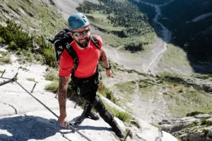
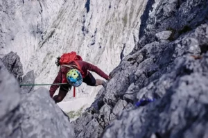
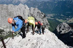
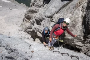
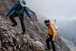
2nd day: Above the Reintaltangerhütte, the last greenery soon disappears in the scree and moraine debris. Bend after bend you climb up to the 2,051 m high Knorrhütte, which towers like a last outpost of civilization like a pulpit above the Reintal. Continue along the well-marked trail, which, depending on the time of year, is sometimes more or less hidden under the remains of old snow. In the midst of this glacial primeval landscape, lifts and the Zugspitzbahn station at Sonnalpin bear witness to the lively development history of Germany's highest mountain. But this also has its good side. Because if bad weather threatens or your fitness and altitude want to play tricks on you, the cog railroad or the summit cable car are a welcome aid or means of escape. The last three hundred meters are the most challenging of the entire ascent. Initially arduous and strenuous through steep scree, later secured with wire ropes, the path leads over numerous rock steps to the airy south ridge and on to the summit. Speaking of the summit. The actual Zugspitze summit is the 2,962 m high east summit. A short "via ferrata" with a particularly exposed final summit ridge leads from the visitor platform up to the striking cross. However, the efforts of the 6 - 7 hour tour are forgotten when you see the view from the Zugspitzplatt over the sea of peaks!
Note on program changes:
All courses and guided tours are conscientiously organized and carried out in accordance with the safety standards of the Vivalpin Mountain and Ski School with qualified specialists (e.g. mountain and ski guides, mountain hiking guides, etc.). The provisional tour program may be adjusted for safety-related reasons, such as bad weather, dangerous conditions, unforeseen natural events or inadequate conditions of the participants. The final program will be decided by the guide on site.
- Surefootedness
- Condition for six to seven hours of hiking (pure walking time).
- Stamina and fitness for up to 1,600 m ascent.
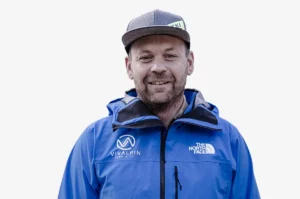
"You need to bring some time and a good level of fitness for the first ascent.
The impressions on the tour will inspire you, I hardly know a more varied tour.
As with the ascent over the Gatterl, you have a backup with the summit lift on the summit day. This shortens the last 300 and most strenuous meters in altitude."
Markus Vogl
State-certified army mountain guide
Member of the VIVALPIN Competence Team


Similar tours
Private mountain guide:in

Want a dream tour? We will be happy to organize an optimally qualified guide for you and your friends, family or company. Over 80 mountain guides are looking forward to your dream tour with you. They have turned their hobby into a profession and will accompany you with great commitment after meticulous preparation. There are virtually no limits: From...
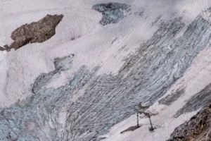
Glacier and climate excursion
Glaciers have always fascinated people. They are natural wonders, sensitive ecosystems, water reservoirs, places of beauty, permanence and change all at the same time. The Northern Schneeferner on the Zugspitzplatt is one of the last four glaciers in Germany and an excellent illustrative example of current climatic developments and the geological background. Learn all about the wonderful natural phenomenon of glaciers! Accompany...

Zugspitze Trek
The Zugspitz Trek is one of our favorite hikes and a classic in the Vivalpin program. The highlight of the tour is undoubtedly the ascent of the 2,962 m high Zugspitze, Germany's highest peak. The extraordinarily beautiful route takes you along easy paths through densely wooded valleys, over sunny crossings and finally over the eternal ice of the Schneeferner to the Zugspitze....
Zugspitze Höllental

The most beautiful ascent to the Zugspitze leads through the Höllental. The challenging mountain tour offers a lot of variety on 2,200 meters of ascent, from easy hiking trails to moderately difficult via ferrata passages to a glacier climb.
Zugspitze Iron Age

First climbed in 2014, the Iron Age with a wall height of 1,200m and difficulties up to IV is today one of the classics on the Zugspitze.
Alpspitz Ferrata
The Alpspitz Ferrata is without doubt one of the most beautiful via ferratas in the Northern Alps. It skilfully avoids all steep steps and leads purposefully in moderate difficulty (B) to the summit. Attention: On the descent via the east shoulder there are still some airy climbing passages.

Zugspitze gate
The route from Ehrwald via Gatterl to the 2,962m high Zugspitze is the easiest and shortest way to Germany's highest peak. It is technically easy and entertaining, but at the same time rewards with fantastic views.
Zugspitze stopper puller

The ascent from Eibsee via Wiener Neustädter Hütte is the least frequently used of the classic Zugspitze routes. It is more demanding than the route through Reintal and less spectacular than the Höllental route. "The golden mean" of the three classic Zugspitze ascents.
Zugspitze Anniversary Ridge
The Jubiläumsgrat is one of the great classic ridge crossings of the Alps. The exposed climbing is an absolute pleasure with the appropriate experience, surefootedness and endurance on the rope of your mountain guide.